Carving the Cosmos: An Arizona Star Map In Stone
To sum up the elements of this solstice marker and star map in stone, we have found an exact indicator for the first day of summer as well as a representation of all the constellations in the Winter Hexagon: Orion, Taurus, the Pleiades, Auriga, Gemini, Canis Minor and Canis Major. (Diagram 2 is a sky chart that has been rotated 180 degrees to correlate with petroglyph orientation shown in Diagram 1.)
Echoing the hermetic maxim "As above, so below," this petroglyph grouping in Arizona includes not only the solar and the stellar but also the tellurian dimension. If we orient the elements of the Homolovi petroglyph to various geographical and human-made features on the landscape, a precise map of the southwestern edge of the Colorado Plateau begins to take shape. The center of the equilateral cross, for instance, corresponds to Tuuwanasavi, or the Hopi Mesas. On the upper end of the vertical axis is a natural hole in the rock over which a somewhat eroded but recognizable small equilateral cross has been abraded. This correlates to the ruins of Betatakin and Kiet Siel in Tsegi Canyon due north of the Hopi Mesas. Approximately the same number of inches below the intersection point, just to the right of the vertical axis, is a faint mark in the rock that represents Homolovi itself. If the Hopi Mesas were indeed first settled circa A.D. 1100 like archaeologists believe, then the Hisatsinom living at this spot where the petroglyph panel is located would certainly have recognized the well-established Center-place off to the north. After all, the first settlement at Homolovi came more than 150 years later. Significantly, Betatakin and Homolovi are equidistant on this north-south axis and were built at about the same time, viz., the latter half of the 13th century.
The plumed serpent petroglyph (the oblique axis of the large equilateral cross) may well represent water, specifically the Little Colorado River that snakes from the southeast to the northwest and joins the Colorado River at the Grand Canyon. To the right on the lower portion of the oblique axis is an incised mark in the rock just above the extended length of the serpent. This represents the Canyon de Chelly pueblo ruins. In addition, the tip of the serpent's tail might correspond to the Casa Malpais and Raven Site ruins in the southeast near the source of the Little Colorado. To the left on the upper portion of the oblique axis midway between the intersection and the serpent's head is a right angle turn that represents the Wupatki pueblo ruins. Moreover, the serpent's head itself could be linked with the smaller ruins in Glen Canyon along the Colorado River north of the Grand Canyon.
East of First Mesa nearly 140 miles are the vestiges of a grand ceremonial city in Chaco Canyon, which is represented in a proportional distance on the Homolovi petroglyph grouping by the antelope. If we look in the opposite direction at the extension of the spiral, we see that the trail roughly follows the geographic arcing of the Colorado River as it flows downstream, terminating at the clan petroglyphs mentioned above, in particular the Bear Clan and the Snake Clan. Some believe that the Hisatsinom traveled upstream and through the Grand Canyon to arrive at the "Sipapuni," where they emerged to seek their final destination upon the Colorado Plateau.
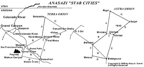
If we look closer at the earth/sky map, focusing on one constellation in particular, we are startled to find that a terrestrial Orion closely reflects its celestial counterpart, with prehistoric "cities" corresponding to every major star in the constellation. (See "Anasazi Star Cities" map.)
Extending from the giant hand of Arizona's Black Mesa that juts down from the northeast, three great fingers of rock beckon. They are the three Hopi Mesas, isolated upon this desolate but starkly beautiful landscape to which the Ancient Ones so long ago were led. Directing our attention to this "Center of the World," we clearly see the close correlation to Orion's Belt. Mintaka, a double star and the first of the trinity to peek over the eastern horizon as the constellation rises, corresponds to Oraibi and Hotevilla on Third (West) Mesa. The former village is considered the oldest continuously inhabited community on the continent, founded in the early 12th century. As recently as 1906, the construction of the latter village proved to be a prophetic, albeit traumatic event in Hopi history precipitated by a split between the Progressives and the Traditionalists. About seven miles to the east, located at the top of Second (Middle) Mesa, Shungopovi is reputed to be the first village established after the Bear Clan migrated into the region circa A.D. 1100. Its celestial correlative is Alnilam, the middle star of the Belt. About seven miles farther east on First (East) Mesa, the adjacent villages of Walpi, Sichomovi, and Hano (Tewa) --the first of which was settled prior A.D. 1300-- correspond to the triple star Alnitak, rising last of the three stars of the Belt.
25 miles northeast of Shungopovi is Burnt Corn ruin close to the village of Pinyon on Black Mesa. Nearby is a spring that is considered the summer home of the Hopi kachinas. These masked intercessory spirits can take the form of any manifold physical object,
phenomenon, or creature found in the world. The sidereal correlation to this specific
region is the Great Orion Nebula (M-42 and M-43) located in the Sword that hangs
down from his Belt.
Nearly due north of Oraibi at a distance of just over 56 miles is Betatakin ruin in Tsegi
Canyon, while about four miles beyond is Kiet Siel ruin. Located within the
boundaries of Navaho Monument, both of these spectacular cliff dwellings
were built after the mid-13th century. Their sidereal counterpart is the double star
Rigel, the left foot or knee of Orion. (We are conceptualizing Orion as viewed from the
front.) Due south of Oraibi approximately 56 miles is Homolovi Ruins State Park, where
our petroglyph panel is located. This group of four pueblo ruins constructed between
the mid-13th and early 14th centuries represents the irregularly variable star
Betelgeuse, the right shoulder of Orion. Almost 47 miles southwest of Oraibi is the primary ruin at Wupatki National Monument, surrounded by a few smaller ruins. Built in the early 12th century, their celestial counterpart is Bellatrix, a slightly variable star forming the left shoulder of Orion. About 50 miles northeast of Walpi is the mouth of Canyon de Chelly, where the eponymous national monument is located. In this and its side Canyon del Muerto a number of ruins dating from the mid-11th century are found. Saiph, the triple star forming the right foot or knee of Orion, corresponds to these ruins, primarily White House, Antelope House, and Mummy Cave.
Extending northwest from Wupatki/Bellatrix, Orion's left arm holds a shield over numerous smaller ruins in Grand Canyon National Park, including Tusayan near Desert View on the south rim. Extending southward from Homolovi/Betelgeuse, Orion's right arm holds a nodule club above his head. This club stretches across the Mogollon Rim (the southern edge of the Colorado Plateau which cuts across northern Arizona) and down to other ruins in the Verde Valley. As a small triangle formed by Meissa at its apex and by Phi 1 and Phi 2 Orionis at its base, the head of Orion correlates to the ruins at Walnut Canyon National Monument together with a few smaller ruins in the immediate region.
If we conceptualize Orion not as a rectangle but as a polygon of seven sides, more specifically an "hourglass" (connoting Chronos) appended to another triangle whose base rests upon the constellation's shoulders, the relative proportions of the terrestrial Orion coincide with amazing accuracy. The apparent distances between the stars as we see them in the constellation (as opposed to actual light-year distances) and the distances between these major Hopi village or Hisatsinom ruin sites are close enough to suggest that something more than mere coincidence is at work here. For instance, four of the sides of the heptagon (A. Betatakin to Oraibi, B. Oraibi to Wupatki, C. Wupatki to Walnut Canyon, and F. Walpi to Canyon de Chelly) are exactly proportional, while the remaining three sides (D. Walnut Canyon to Homolovi, E. Homolovi to Walpi, and G. Canyon de Chelly back to Betatakin) are slightly stretched in relation to the constellation-- from 10 miles in the case of D. and E. to 12 miles in the case of G. (See "Anasazi Star Cities" map above.)
This variation could be due either to cartographic distortions of the contemporary sky chart in relation to the geographic map or to ancient misperceptions of the proportions of the constellation vis-á-vis the landscape. Given the physical exigencies for building a village, such as springs or rivers, which are not prevalent in the desert anyway, this is a striking correlation, despite these small anomalies in the overall pattern.
On each summer solstice the Hisatsinom witnessed worlds of shadow and sunlight interact with amazing complexity, evoking beyond a doubt the discernible presence of the divine. Unlike our modern denizens of chaos and despair, these ancient souls lived in a cosmos where the Earth truly mirrored the sky. For us securely ensconced in the secular world of rationalism, scientific empiricism, and technological gadgetry, this grouping of petroglyphs in Arizona is a mute mystery play whose deeper implications have been irretrievably lost in the intervening seven hundred years of cultural and psychological dislocations. Beyond the academic speculations it engenders, this rock surface provides a dream screen upon which we project our desires for a unified cosmology complete with its holistic framework of ritual and myth. For its makers in the late 13th century, on the other hand, the carved panel was undoubtedly a manifestation of the numinous forces inherent in a vibrant world where the membrane between the physical and the spiritual was as diaphanous as a breath.
Article copyrighted © 2001-2002 by Gary A. David. All rights reserved. Any use of the text, the map, or the photographs without the author's prior consent is expressly prohibited.
Gary A. David is an independent researcher and writer living in rural Arizona. This essay is an excerpt from his forthcoming book entitled "The Orion Zone: Ancient Star Cities of the American Southwest." He recently published an essay in Crichton Miller's new book called "The Golden Thread of Time," featured in the January/February 2002 issue of Ancient American magazine.
For more articles on "The Orion Zone," go to the web site of the same name: www.azorion.tripod.com
(continued) 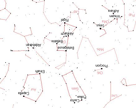

Other history related articles on this site:
.
.
.
.
.
.
.
.
.
.
.
.
If you have a suggestion or history related article to submit, send it to:
Editor/viewzone.com
myristicin@hotmail.com